|
Looking Ahead
All Day Saturday & Sunday
ALL DAY NO. A0702-248 June 10
AT: Spivey Gap to Nolichucky River 8:00 AM
Hike 11, Drive 110, 1400 ft. ascent, Rated A-B
Chip Miller, 828-654-9331, backpacker54nc@bellsouth.net
This AT sequence hike is the first section north of CMC’s maintenance sections. The hike features beautiful woods and striking views of the Nolichucky Gorge as we drop down to the end point at the hostel at the Nolichucky River .Car shuttle. Topo: Chestoa
ALL DAY NO. A0702-376 June 17
Mt. Le Conte via Rainbow Falls and Bullhead Trails 8:00 AM
Hike 13, Drive 180, 3900 ft. ascent, Rated AA-AA+
Don Gardner, 828-754-4067, gardog3@charter.net
900M From Cherokee Orchard near Gatlinburg, we’ll ascend Rainbow Falls Trail, stopping to look at the falls, and then to a late but spectacular lunch spot at Cliff Top on Mt. Le Conte; we’ll descend on scenic Bullhead Trail. A long day and strenuous hike, but the evenly-graded trails make it easier. Second meeting place: Pilot Truck Stop at exit 24 off I-40 at 8:30 AM. Topo: Mt. Le Conte; also Nat’l. Geo. GSMNP map
Half Day Sunday
HALF-DAY No. H0702-465 June 10
Sam Knob Loop 1:00 PM*
Hike 5, Drive 70, Rated C-B, 1200 ft. ascent
Nonmembers, call leader, Joe Burchfield, 828-298-8413 , burchfield@niu.edu
SB6K, P400 *Note early start time. From the parking lot at the end of Forest Service Road 816 off the Blue Ridge Parkway, we will take the Sam Knob Trail to the Flat Laurel Creek Trail, with a side trip up 6040-ft. Sam Knob, then through a spruce forest to return. Second meeting place: BRP Cold Mtn. overlook at 1:35 PM
HALF-DAY No. H0702-453 June 17
Max Patch Ramble 1:30 PM
Nonmembers, call leader, Gail Lamb, 828-350-0450, galmb46@aol.com
Hike 5.5, Drive 104, Rated B-C
Awesome panoramic views and late spring wildflowers make this moderate hike a favorite. We will go up Max Patch to the Appalachian Trail and north through meadows, woods and across a small stream. We’ll then loop back on a side trail.
All Day Wednesday
WEDNESDAY NO. W0702-273 June 6
Boogerman Loop 9:00 AM*
Hike 8, Drive 90, 1000 ft. ascent, Rated B-B
Ashok Kudva, 828-698-7119, ashok.kudva@mchsi.com
900M *Note later start time. A lush forest with giant old-growth Tulip trees and remnants of pioneer life make this a favorite loop hike in the Cataloochee area of the Smokies. If we’re lucky we may spot one of the elk. Second meeting place: Pilot truck stop at exit 24 off I-40 at 9:30 AM, but call leader first. Topos: Cove Creek Gap, Dellwood; also Nat’l. Geo. GSMNP map
WEDNESDAY NO. W0702-270 June 13
Cedar Rock Mtn-John Rock Loop 8:30 AM*
Hike 8, Drive 80, Rated B-A
Charlie Ferguson, 828-398-0215, ccf108@gmail.com
P400 *Note later start time. This trip features two of the spectacular rock summits in the Pisgah Forest, with great views from both. Starting at the Fish Hatchery, we’ll have our major climb up to Cat Gap and then on to Cedar Rock for lunch. We’ll return via John Rock. Second meeting place: Pisgah Fish Hatchery at 9:10 AM. Topo: Shining Rock; also Nat’l. Geo. PNF map
WEDNESDAY NO. W0702-566 June 20
Roans in Bloom 8:30 AM*
Hike 8, Drive 150, 1000 ft. ascent, Rated B-B
Adrian Lotherington, 828-484-9132, jaloth@charter.net
SB6K A beautiful AT hike with some of WNC’s finest views. Expect rhododendrons and flame azaleas to be in bloom, with perhaps an early Gray’s lily. From Carver’s Gap we’ll go north past Grassy Ridge (6160 ft.) to a scenic overlook for lunch, then double back south to Carvers Gap. From here we’ll drive up to see the Rhododendron Gardens and the vista from Roan High Bluff (6287 ft.). (small fee to enter garden area) *Only Meeting Place: Rose's Car Park, across from McDonalds at the US 25/70 Weaverville Exit #19 at 8:30 AM. For any questions, please phone leader. Topo: Carvers Gap; also Nat’l. Geo. South Holston & Watauga Lakes map
Looking Back......
All Day Saturday & Sunday
ALL DAY NO. A0702-033 May 27
Ramsey Cascades 8:00 AM
Hike 8, Drive 160, 2000 ft. ascent, Rated B-AA
Janet Martin, 812-738-8154, jaykaymartin@msn.com
900M This is one of the classic hikes in the Smokies. We will pass through a grove of old-growth tulip poplars on our way to sixty-foot high Ramsey Cascades, located in a rich forested glen. The drive and effort to reach this trail are a small price to pay for the reward. Second meeting place: Pilot Truck Stop at exit 24 off I-40 at 8:30 AM. Topo: Mt. Guyot; also Nat’l. Geo. GSMNP map
 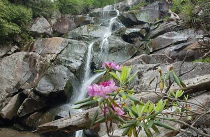
After a four mile steady climb, 13 determined hikers enjoyed the cool breeze during lunch at the foot of the Ramsay Cascades. As the water level was low, we were able to cross over the stream to view the terraced fall from an unusual angle. On the return route, we saw one ring neck, two red squirrels, 3 huge, stately tulip poplars, and finally four very dusty vehicles after crossing five log footbridges. Due to poor timing by the hike leader, the CMC group missed the sow and cubs as well as papa bear, which were reportedly seen by other hikers on this pleasant late May day. Janet.Photos by Ted Connors
Bruce Bente added.
After the hike, eight hungry hikers enjoyed a delicious supper at the nearby Bear Creek Grille. Our leader unfortunately was unable to join us, having instead chosen a 6-hour drive home to Indiana.
MEMORIAL DAY JOINT HIKE WITH SMOKY MTNS. HIKING CLUB
ALL DAY NO. A0702-089 May 28
AT: Max Patch to Lemon Gap and Return 8:00 AM
Hike 11, Drive 100, 1800 ft. ascent, Rated A-A
Becky Smucker, 828-298-5013, bsmucker@charter.net
Our annual joint hike with Smoky Mountains Hiking Club will begin and end at Max Patch to enjoy one of WNC’s most stunning views, hike along a beautiful section of the AT, and see the new AT shelter recently built by CMC. Second meeting place: Pilot Truck Stop at exit 24 off I-40 at 8:30 AM. Topo: Lemon Gap
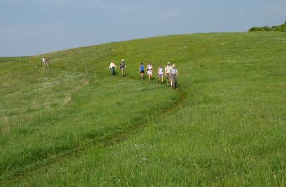 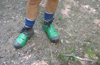
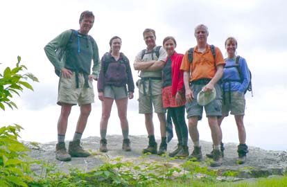
Thirty-eight (yes, 38) upbeat hikers from CMC and the Smoky Mountains Hiking Club gasped and choked their way through clouds of road dust to the Max Patch parking lot. We were just about wishing for a good downpour, but no such luck; the drought continued through the day so we had to put up with good weather. Views from the top of the bald were enjoyable although distant ranges were hazy with smoke from fires to the south and west. This was a little late for the peak of spring flower fairyland along the A.T., but we still enjoyed the variety of plants in bloom, the spectacular birdsongs and the fresh, full green of the woods. We were proud to show off the new Roaring Fork Shelter and its “facilities”. Everyone seemed to enjoy meeting members from the other club and comparing club ideas and experiences. The Smoky Mountain folks suggested that maybe our next hike together could be in the same place but at the peak of fall color. Becky Smucker. Photos by Danny Bernstein. The photo on the right was of an emergency boot repair on the trail.
National Trails Day
Celebrate National Trails Day by hiking in the Little Cataloochee Valley. Kevin FitzGerald, Deputy Superintendent of the Great Smoky Mountains National Park, will be hiking with us. Choose from an easy half-day hike or a challenging climb.
SATURDAY ALL-DAY NO. A0702-561 June 2
Mt. Sterling from Cataloochee 8:00 AM
Hike 13.3, Drive 100, 3300 ft. ascent, Rated AA-AA
Danny Bernstein, 828-236-0192, danny@hikertohiker.org
900M The views on Mt. Sterling are awesome. Starting at the Little Cataloochee Trailhead, we’ll hike up the Long Bunk Trail past Hannah Cemetery. Then we turn on the Mt. Sterling Trail, an old jeep road, which makes the climbing easier than it sounds. There will be wildflowers and views as we go up. Second meeting place: Pilot truck stop at exit 24 off I-40 at 8:30 AM. Topo: Cove Creek Gap; also Nat’l. Geo. GSMNP map
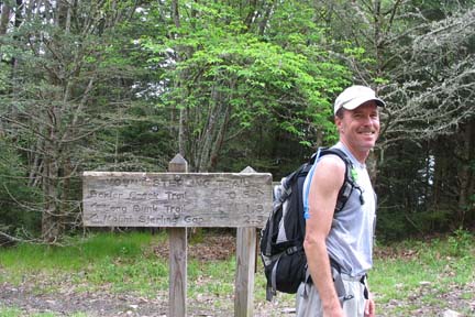 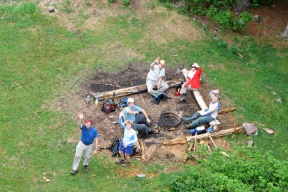
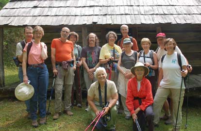
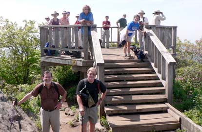
Both groups met at the Little Cataloochee Trailhead. Kevin FitzGerald talked for a few minutes about the importance of trails and that's ultimately what the park was all about. And then we started hiking. The views on top of Mt. Sterling were awesome. But first we had to climb up to the mountain. As we huffed and puffed our way up, we noticed how dry the soil was. Even the Smokies, usually much wetter than the surrounding area, had trickles instead streams. The top was fogged in but it didn't matter. We were on top enjoying our lunch. Kevin FitzGerald, who hiked with us, made a point of talking to each hiker and told several funny "ranger" stories. Our group finished up at J. Arthur's for dinner. Diamond Brand Outdoors cosponsored CMC's National Trails Day event and everyone received a map of the Smokies and a Cliff bar. Thank you, Diamond Brand. Danny. Photos by Danny Bernstein. On the left is Kevin out of his NPS uniform. The picture on the right was taken from the tower looking down.
SATURDAY HALF-DAY NO. H0702-557 June 2
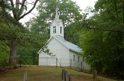
Little Cataloochee Church 8:00 AM
Hike 5 miles, Drive 100, Rated C-C
Nonmembers, call leader, Jean Gard, 828-777-1814, jeangard@charter.net
900M Hike to the Little Cataloochee Church and cemetery on a good jeep road, with a short diversion to the Hannah Cemetery. Residents in this vibrant Little Cataloochee community had to leave when the area became the Great Smoky Mountains Nat’l. Park. After the hike, those who wish can drive to the Big Cataloochee valley and see the church, school and other structures. Second meeting place: Pilot truck stop at exit 24 off I-40 at 8:30 AM. Topo: Cove Creek Gap also Nat’l. Geo. GSMNP map
Nine CMC members and five guests celebrated National Trails Day in the Little Cataloochee and Big Cataloochee valleys. This was a six-mile hike through a land that once teemed with farms, orchards, houses, horses, and about 1500 settlers. The valleys were occupied for one long lifetime of about one hundred years, before the Great Smoky Mountains National Park was created, the people relocated, and most of the buildings razed. We visited the Hannah Cemetery just a day before the descendents’ annual Decoration Day, when descendants visit and place flowers on their family graves, then gather on the church grounds for a day-long picnic.
We also stopped at the well-preserved Hannah Cabin, the quiet, quaint Little Cataloochee Chapel and a cabin and remains of a barn that once housed huge apple crops that Cataloocheans raised and sold all over Western North Carolina.
After the hike, we drove over to Big Cataloochee, visiting the Palmer Chapel, the schoolhouse and the Caldwell house The elks, however, were not at home for our visit. We should have called first. Jean Gard. Photos by Ted Connors
ALL DAY NO. A0702-449 June 3
Bald Mtns. Loop 8:00 AM
Hike 9.7, Drive 135, 2900 ft. ascent, Rated A-AA
Les Love 828-658-1489 lesrlove@aol.com
This is a beautiful Tennessee hike only 1 1/4 hours away. We'll hike from the Horse Creek Rec. Area to Pete's Branch Falls, then up Sarvis Cove along the creek to the AT at Cold Spring Mountain for lunch. We'll go back down an old jeep road that has great views. This hike is strenuous and has seven rock-hop creek crossings that may involve wading, so come prepared. Topo: Greystone; also Nat’l. Geo. French Broad & Nolichucky Rivers map
Catherine and I took our kids on the ride over for this hike to spend the day in Tennesee with my parents. 4 others (making 6 to do the hike) showed up at Westgate, where it was raining, but the weather improved by the time we got to the trailhead. We visited Pete's Branch Falls (very little water) and after the strenuous climb up Sarvis Cove, we had 2 thru hiker visitors for lunch on the A.T. at Cold Springs Meadow. Our day was topped off by an early supper at the Farmer's Daughter - an incredible family style restaurant near the trail head. Les. Photos by Charlie Ferguson.
Half Day Sunday
HALF-DAY No. H0702-349 May 27
Buck Spring Trail 1:00 PM
Hike 6.2, Drive 50, Rated B-C
Nonmembers, call leader, Paula Robbins, 828-281-3253, paularww@bellsouth.net
This pleasant down-hill hike starts at the Pisgah Inn and ends at Rt. 276, with a car spot. Call the leader if you wish to join her for dinner at the Pisgah Inn after the hike. Second meeting place: Pisgah Inn parking lot near convenience store at 1:30 PM.
[No Report]
HALF-DAY NO. H0702-525 June 3
Dupont Forest: Corn Mill Shoals P.L. #2 12:30 PM*
Hike 4 miles, Drive 94, Rated C-C
Nonmembers, call leader, Becky Elston, 828-749-1886, belston@cytechusa.com
A pleasant hike over several trails up and over the granite slabs of Cedar Mountain with a break at the top of Bridal Veil Falls. *Note early start time. Meet at Westgate at 12:30 PM to form carpools, and meet hike leader at Hooker Falls Parking Lot at 1:15 PM.
The Mountain Laurel were still spectacular. We had a small group who enjoyed Dupont's Cedar Rock and Bridal Veil Falls from many different angles (top, under falls, sitting next to rushing water, expanse of the falls).Becky
Wednesday
WEDNESDAY NO. W0702-491 May 23
Miami Mtns Watershed Hike 8:40 AM*
Hike 6, Drive 40, 1750 ft. ascent, Rated B-A
Tommy Boston, 828-686-5029 (cell after 8 AM, 279-8410), Tambee2@aol.com.
Strenuous hike! This is the second time the club will hike the Miami Mtns watershed from Ridgecrest Boys Camp to Christmount Christian Assembly. Some steep uphills and good views of the Craggys. *Meeting places: Meet at Westgate at 8:40 AM to form carpools, and meet leader at parking lot adjacent to McDonald's at exit 64 of I-40 at 9:00 AM. Topo: Black Mtn.
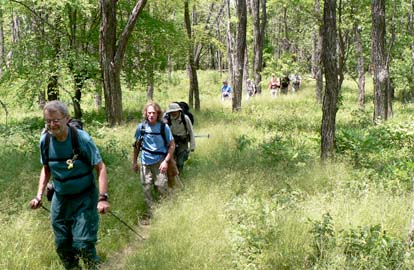
 Hazy and warm weather accompanied twelve hikers from Ridgecrest Boys Camp to Christmount Christian Assembly. We began the hike on the old Catawba Falls trail, then followed the last eastbound creek on the continental divide to the western side where water flows into the Swannanoa River. Hazy and warm weather accompanied twelve hikers from Ridgecrest Boys Camp to Christmount Christian Assembly. We began the hike on the old Catawba Falls trail, then followed the last eastbound creek on the continental divide to the western side where water flows into the Swannanoa River.
We semi-bushwhacked the Miami Mountains to include Job's Peak and Evan's Knob. Burgin's reservoir was visible, but Dunsmore Cove and Christmount watershed were obscured by leaves. The in-between-season flowers were few but did include, wild geranium, wild hydrangea, blue eyed star grass, every laurel bush in sight, mountain roses, bellwort, spiderwort, and one blaze azalea. The high pollen count on this hike came from the chinquapin tree. Tommie Boston. Photo by Ted Connors.
WEDNESDAY NO. W0702-447 May 30
MST: Mt. Pisgah to Beaver Dam Overlook 9:00 AM*
Hike 8, Drive 45, 1500 ft. ascent, Rated B-B
Joe Burchfield, 828-298-8413, Burchfield@niu.edu
P400 Note later start time. This moderate hike will start with a round trip up and down Mt. Pisgah, and will then follow the MST northbound to Beaver Dam Overlook. Expect good views along the route. Short car shuttle. Second meeting place: BRP French Broad overlook at 9:10 AM. Topos: Cruso, Dunsmore Mtn.; also Nat’l. Geo. PRD map & MST Profiles, pg. 53-55
On a warm sunny day, nineteen hikers (including two who were new to
CMC) drove up the BRP to the parking lot at Mount Pisgah. Bruce Bente
led the group in the first stage of the hike to the top of Mount Pisgah
while I, suffering from allergies, served as sweep and followed at a more leisurely pace. Haze made the view from the top less than ideal,
but nonetheless, Tom Bindrim provided some of us with a guided identification of the peaks that were visible.
Returning to the parking
lot we proceeded over Little Pisgah on the MST-Shut In Trail. We paused
for lunch at a rock field about half way down Little Pisgah Ridge and
then proceeded to Elk Pature Gap where we joined Carol Deal and Sherman
Stambaugh who had elected not to climb Mount Pisgah. After another
unplanned but extremely pleasant break (this really was a leisurely
hike), we continued on past some fine examples of the original stone
work from the Vanderbilt era on the Shut In Trail to Beaver Dam Gap.
Although the abundance of ground level wild flowers was a bit
disappointing for this time of year the mountain laurel was in full
bloom. It was a very good day. Joe Burchfield. Photos by Charlie Ferguson
All-day hikes submitted by Bruce Bente 692-0116, bbente@bellsouth.net . Driving distance is round-trip from Asheville. All Saturday and Sunday hikes assemble at Westgate Shopping Center near I-240 UNLESS OTHERWISE NOTED.
Half Day hikes submitted by Paula Robbins 828-687-1651 paularww@bellsouth.net.
Wednesday Hikes are submitted by Charlie Ferguson, 828-398-0213 ccf108@gmail.com and Ann Gleason, 828-859-9387,
gleason.ann@gmail.com .
The meeting place for each hike will be designated by the hike leader and will appear in the hike description.
Driving mileage will be listed, round trip, from the first designated meeting place.
Leaders: Mail please mail your sign-up sheets. Meet at Westgate unless otherwise noted. |
 CMC Bi-Weekly Hike News